
Make a donation
Gear up for your next adventure:
As an Amazon Associate, this site earns from qualifying purchases at no extra cost to you.
Lashmeet topographic map
Click on the map to display elevation.
Make a donation
Gear up for your next adventure:
As an Amazon Associate, this site earns from qualifying purchases at no extra cost to you.
About this map
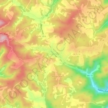
Name: Lashmeet topographic map, elevation, terrain.
Location: Lashmeet, Mercer County, West Virginia, 24747, United States (37.40030 -81.21597 37.44030 -81.17597)
Average elevation: 2,598 ft
Minimum elevation: 2,123 ft
Maximum elevation: 2,940 ft
Mercer County trails, hiking, mountain biking, running and outdoor activities
Make a donation
Gear up for your next adventure:
As an Amazon Associate, this site earns from qualifying purchases at no extra cost to you.
Other topographic maps
Click on a map to view its topography, its elevation and its terrain.
Pinnacle Rock State Park
United States > West Virginia > Mercer County > Nemours
Average elevation: 2,533 ft