Geolocate

Boston topographic map

Click on the map to display elevation.

About this map

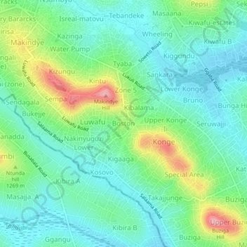
Name: Boston topographic map, elevation, terrain.

Location: Boston, Kampala, Central Region, 12416, Uganda (0.25121 32.57929 0.29121 32.61929)

Average elevation: 3,878 ft

Minimum elevation: 3,724 ft

Maximum elevation: 4,275 ft

Gear up for your next adventure:

🏫Relief Map Kits - Hands-on tools for teaching landforms and elevation
🔦Compact Flashlight - Reliable flashlight for emergencies
📻Weather Alert Radios - Stay informed of storm risks while off-the-grid
🪓Survival Multi‑Tool - Versatile tool for camp and trail tasks
🏕️Tent Footprint - Protect your tent base from wear

As an Amazon Associate, this site earns from qualifying purchases at no extra cost to you.