Geolocate

Bagbag topographic map

Click on the map to display elevation.

About this map

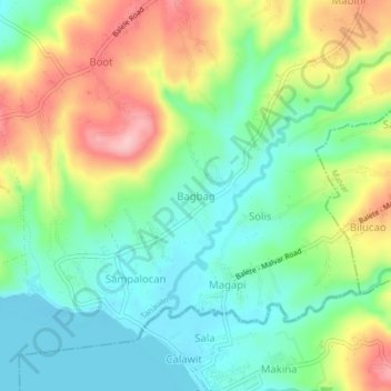
Name: Bagbag topographic map, elevation, terrain.

Location: Bagbag, Tanauan, Batangas, Calabarzon, 4232, Philippines (14.01776 121.07363 14.05776 121.11363)

Average elevation: 207 ft

Minimum elevation: 3 ft

Maximum elevation: 541 ft

Other topographic maps

Click on a map to view its topography, its elevation and its terrain.

Maria Paz

Philippines > Batangas > Tanauan

Average elevation: 210 ft

Barangay 3

Philippines > Batangas > Tanauan > Hidalgo

Average elevation: 518 ft

Barangay 5

Philippines > Batangas > Tanauan > Hidalgo

Average elevation: 505 ft

Suplang

Philippines > Batangas > Tanauan

Average elevation: 810 ft

Barangay 5

Philippines > Batangas > Tanauan > Hidalgo

Average elevation: 505 ft

Gear up for your next adventure:

🗺️NatGeo Topo Maps - High-quality waterproof printed topographic maps of US Parks
🧭GPS Watch Accessories - Bands and chargers for GPS watches
🌲Outdoor Survival Books - Best books on survival skills
📦Gear Storage Bags - Organize and protect outdoor equipment
🧦Merino Wool Socks - Moisture-wicking, blister-preventing socks for long treks

As an Amazon Associate, this site earns from qualifying purchases at no extra cost to you.