
Thank you for supporting this site ❤️
Make a donation
Make a donation
Gear up for your next adventure:
As an Amazon Associate, this site earns from qualifying purchases at no extra cost to you.
Alpharetta topographic map
Click on the map to display elevation.
Thank you for supporting this site ❤️
Make a donation
Make a donation
Gear up for your next adventure:
As an Amazon Associate, this site earns from qualifying purchases at no extra cost to you.
About this map
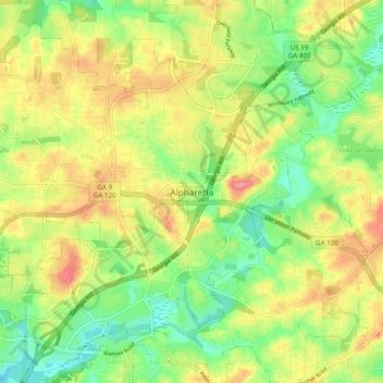
Name: Alpharetta topographic map, elevation, terrain.
Location: Alpharetta, Fulton County, Georgia, 30009, United States (34.03096 -84.31473 34.11096 -84.23473)
Average elevation: 1,066 ft
Minimum elevation: 932 ft
Maximum elevation: 1,224 ft
Thank you for supporting this site ❤️
Make a donation
Make a donation
Gear up for your next adventure:
As an Amazon Associate, this site earns from qualifying purchases at no extra cost to you.