
Yuanyang topographic map
Interactive map
Click on the map to display elevation.
Yuanyang
It covers an area of 2,200 km2 (850 sq mi) and has a population of approximately 365,000 (2002), of which 88% belong to ethnic minorities and 95% is associated with agriculture. The majority of the inhabitants of the county are from the Hani ethnic group. The GDP of Yuanyang county in 2021 was 9,312 million Yuan. The administrative seat of the county is the town of Nansha (a.k.a. New Yuanyang) down in the Red River valley at an elevation of 240 meters. It is situated 12 km (7.5 mi) towards the north-east of the former administrative seat Xinjie (a.k.a. Old Yuanyang or just Yuanyang) to which it is connected by a 27 km (17 mi) long twisting mountain road. To the south of Old Yuanyang, the town of Panzhihua is positioned near the top of another major valley of rice-terraces. There are a total of 928 settlements in Yuanyang county, 826 of them being inhabited by only one single ethnic group.
About this map
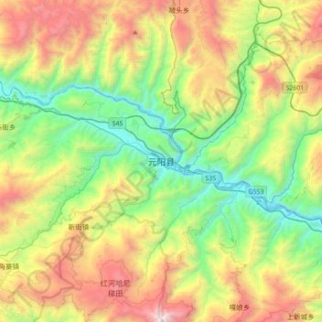
Name: Yuanyang topographic map, elevation, terrain.
Location: Yuanyang, Yuanyang County, Honghe, Yunnan, China (23.06346 102.67437 23.38346 102.99437)
Average elevation: 3,842 ft
Minimum elevation: 640 ft
Maximum elevation: 9,347 ft
Other topographic maps
Click on a map to view its topography, its elevation and its terrain.
Honghe Hani Rice Terraces
China > Yunnan > Yuanyang County > Zhulu
The terraces follow a distinct vertical structure that has allowed the landscape to persist for so long, incorporating forests, villages, terraces, and water supply. At the tops of the mountains (above 2000 meters in elevation), the forests are conserved, to act as a catchment for the rainfall and to…
Average elevation: 5,200 ft