
Make a donation
Gear up for your next adventure:
As an Amazon Associate, this site earns from qualifying purchases at no extra cost to you.
Upper Arlington topographic map
Click on the map to display elevation.
Make a donation
Gear up for your next adventure:
As an Amazon Associate, this site earns from qualifying purchases at no extra cost to you.
Upper Arlington
The city is around 800 ft elevation located between the Olentangy and Scioto rivers. Two ravines cut through the city. The Slate Run in the northwest corner flows into the Scioto River. However, the Turkey Run is longer. It originates in the north then runs southwards until it makes an eastward bend around Reed Rd. Then, it flows eastwards through the OSU Golf Course. The run is used as a storm drain at points, has been dammed in the Ohio State course and runs through concrete pipes at two points. The soil is glacial till and is suitable for agriculture, supporting a research farm operated by Ohio State University.
Make a donation
Gear up for your next adventure:
As an Amazon Associate, this site earns from qualifying purchases at no extra cost to you.
About this map
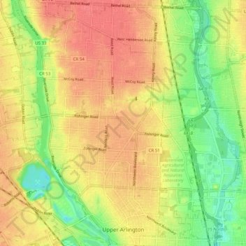
Name: Upper Arlington topographic map, elevation, terrain.
Location: Upper Arlington, Franklin County, Ohio, United States (39.98929 -83.10452 40.06548 -83.04254)
Average elevation: 817 ft
Minimum elevation: 692 ft
Maximum elevation: 915 ft
Franklin County trails, hiking, mountain biking, running and outdoor activities
Make a donation
Gear up for your next adventure:
As an Amazon Associate, this site earns from qualifying purchases at no extra cost to you.
Other topographic maps
Click on a map to view its topography, its elevation and its terrain.
Columbus
United States > Ohio > Franklin County > Columbus
The confluence of the Scioto and Olentangy rivers is just north-west of Downtown Columbus. Several smaller tributaries course through the Columbus metropolitan area, including Alum Creek, Big Walnut Creek, and Darby Creek. Columbus is considered to have relatively flat topography thanks to a large glacier that…
Average elevation: 837 ft
Make a donation
Gear up for your next adventure:
As an Amazon Associate, this site earns from qualifying purchases at no extra cost to you.
Make a donation
Gear up for your next adventure:
As an Amazon Associate, this site earns from qualifying purchases at no extra cost to you.