Geolocate

Cajimos topographic map

Click on the map to display elevation.

About this map

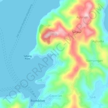
Name: Cajimos topographic map, elevation, terrain.

Location: Cajimos, Romblon, Mimaropa, 5500, Philippines (12.57460 122.25486 12.61460 122.29486)

Average elevation: 207 ft

Minimum elevation: 0 ft

Maximum elevation: 830 ft

Other topographic maps

Click on a map to view its topography, its elevation and its terrain.

Alad

Philippines > Romblon > Romblon

Average elevation: 33 ft

Logbon Island

Philippines > Romblon > Romblon > Logbon

Average elevation: 10 ft

Gear up for your next adventure:

🌐World Map Poster - Decorative world maps with topographic info
👓Polarized Sunglasses - Outdoor sunglasses for glare reduction
🪶Thermal Camp Blanket - Extra warmth for cold nights
☀️Outdoor Sunscreen - High protection sunscreen for outdoor activities
🚗GPS Dash Cams - Record your scenic drives through mountain passes and canyons

As an Amazon Associate, this site earns from qualifying purchases at no extra cost to you.