
Santa Pau topographic map
Interactive map
Click on the map to display elevation.
About this map
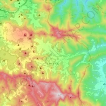
Name: Santa Pau topographic map, elevation, terrain.
Location: Santa Pau, Garrotxa, Gerona, 17811, España (42.11366 2.49372 42.19442 2.62966)
Average elevation: 1,788 ft
Minimum elevation: 699 ft
Maximum elevation: 3,294 ft
Other topographic maps
Click on a map to view its topography, its elevation and its terrain.
Turó de la Rovira
Turó de la Rovira, Santa Pau, Garrotxa, Gerona, 17811, España
Average elevation: 2,264 ft
Volcà del Croscat
Volcà del Croscat, Olot, Garrotxa, Gerona, 17811, España
Average elevation: 2,028 ft