
Thank you for supporting this site ❤️
Make a donation
Make a donation
Gear up for your next adventure:
As an Amazon Associate, this site earns from qualifying purchases at no extra cost to you.
Manzanar topographic map
Click on the map to display elevation.
Thank you for supporting this site ❤️
Make a donation
Make a donation
Gear up for your next adventure:
As an Amazon Associate, this site earns from qualifying purchases at no extra cost to you.
About this map
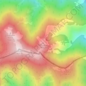
Name: Manzanar topographic map, elevation, terrain.
Location: Manzanar, Villavelayo, La Rioja, 09679, España (42.09124 -3.01337 42.09134 -3.01327)
Average elevation: 5,112 ft
Minimum elevation: 3,845 ft
Maximum elevation: 6,106 ft
Thank you for supporting this site ❤️
Make a donation
Make a donation
Gear up for your next adventure:
As an Amazon Associate, this site earns from qualifying purchases at no extra cost to you.