
Beuren an der Aach topographic map
Interactive map
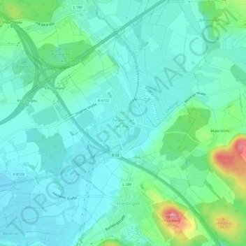
Click on the map to display elevation.
About this map
Name: Beuren an der Aach topographic map, elevation, terrain.
Average elevation: 1,486 ft
Minimum elevation: 1,411 ft
Maximum elevation: 1,759 ft
Beuren liegt auf einer Höhe von 439 m ü. NHN, am Umspannwerk Beuren und am Autobahnkreuz Hegau, das sich komplett auf Gemarkung des Ortes befindet.
Other topographic maps
Click on a map to view its topography, its elevation and its terrain.
Oberes Schloss
Deutschland > Baden-Württemberg > Landkreis Konstanz > Singen (Hohentwiel)
Oberes Schloss, 2, Am Schloßgarten, Nordstadt, Singen (Hohentwiel), Verwaltungsgemeinschaft Singen (Hohentwiel), Landkreis Konstanz, Baden-Württemberg, 78224, Deutschland
Average elevation: 1,473 ft
Bohlingen
Deutschland > Baden-Württemberg > Landkreis Konstanz > Singen (Hohentwiel)
Bohlingen, Singen (Hohentwiel), Verwaltungsgemeinschaft Singen (Hohentwiel), Landkreis Konstanz, Baden-Württemberg, 78224, Deutschland
Average elevation: 1,506 ft