
Make a donation
Gear up for your next adventure:
As an Amazon Associate, this site earns from qualifying purchases at no extra cost to you.
Oberes Schloss topographic map
Click on the map to display elevation.
Make a donation
Gear up for your next adventure:
As an Amazon Associate, this site earns from qualifying purchases at no extra cost to you.
About this map
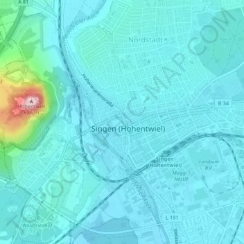
Name: Oberes Schloss topographic map, elevation, terrain.
Average elevation: 1,473 ft
Minimum elevation: 1,378 ft
Maximum elevation: 2,238 ft
Make a donation
Gear up for your next adventure:
As an Amazon Associate, this site earns from qualifying purchases at no extra cost to you.
Other topographic maps
Click on a map to view its topography, its elevation and its terrain.
78224
Deutschland > Baden-Württemberg > Landkreis Konstanz > Singen (Hohentwiel)
Average elevation: 1,516 ft
Beuren an der Aach
Deutschland > Baden-Württemberg > Landkreis Konstanz > Singen (Hohentwiel)
Beuren liegt auf einer Höhe von 439 m ü. NHN, am Umspannwerk Beuren und am Autobahnkreuz Hegau, das sich komplett auf Gemarkung des Ortes befindet.
Average elevation: 1,470 ft