
Make a donation
Gear up for your next adventure:
As an Amazon Associate, this site earns from qualifying purchases at no extra cost to you.
Wemeldinge topographic map
Click on the map to display elevation.
Make a donation
Gear up for your next adventure:
As an Amazon Associate, this site earns from qualifying purchases at no extra cost to you.
Wemeldinge
Sinds 1992 is het echter mogelijk om rechtstreeks door te varen. Dit werd mogelijk doordat een nieuwe aftakking van het kanaal in gebruik werd genomen. De dijken langs het kanaal zijn tot deltahoogte verhoogd.
Make a donation
Gear up for your next adventure:
As an Amazon Associate, this site earns from qualifying purchases at no extra cost to you.
About this map
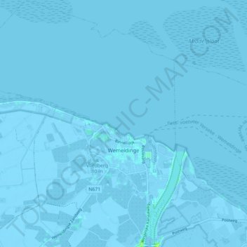
Name: Wemeldinge topographic map, elevation, terrain.
Location: Wemeldinge, Kapelle, Zeeland, Nederland (51.49702 3.93733 51.55155 4.01739)
Average elevation: -3 ft
Minimum elevation: -20 ft
Maximum elevation: 30 ft
Make a donation
Gear up for your next adventure:
As an Amazon Associate, this site earns from qualifying purchases at no extra cost to you.