Geolocate

Watzing topographic map

Click on the map to display elevation.

About this map

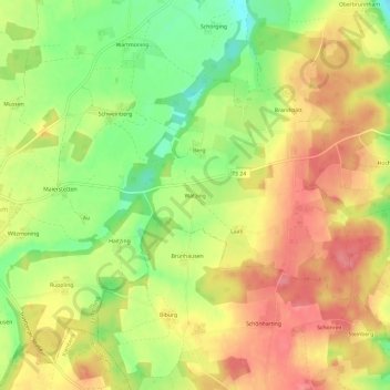
Name: Watzing topographic map, elevation, terrain.

Location: Watzing, Tacherting, Landkreis Traunstein, Bayern, 83342, Deutschland (48.05219 12.50082 48.09219 12.54082)

Average elevation: 1,719 ft

Minimum elevation: 1,572 ft

Maximum elevation: 1,834 ft

Other topographic maps

Click on a map to view its topography, its elevation and its terrain.

83342

Deutschland > Bayern > Landkreis Traunstein > Tacherting > Schweinberg

Average elevation: 1,680 ft

Gear up for your next adventure:

🌧️Backpack Rain Cover - Keep gear dry in wet weather
🔦LED Headlamp - Bright and durable LED headlamp for night navigation
🥄Camping Utensil Set - Lightweight utensils for outdoor meals
🥇GPS Hiking Watch - Multi‑sport GPS watch with navigation and trail tracking
🛡️Insect Repellent - Protection against bugs during outdoor activities

As an Amazon Associate, this site earns from qualifying purchases at no extra cost to you.