
Thank you for supporting this site ❤️
Make a donation
Make a donation
Gear up for your next adventure:
As an Amazon Associate, this site earns from qualifying purchases at no extra cost to you.
Quitaracza topographic map
Click on the map to display elevation.
Thank you for supporting this site ❤️
Make a donation
Make a donation
Gear up for your next adventure:
As an Amazon Associate, this site earns from qualifying purchases at no extra cost to you.
About this map
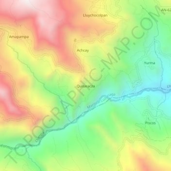
Name: Quitaracza topographic map, elevation, terrain.
Location: Quitaracza, Llumpa, Mariscal Luzuriaga, Áncash, Perú (-9.01365 -77.49545 -8.97365 -77.45545)
Average elevation: 10,791 ft
Minimum elevation: 9,268 ft
Maximum elevation: 12,638 ft
Thank you for supporting this site ❤️
Make a donation
Make a donation
Gear up for your next adventure:
As an Amazon Associate, this site earns from qualifying purchases at no extra cost to you.