Geolocate

Beri topographic map

Click on the map to display elevation.

About this map

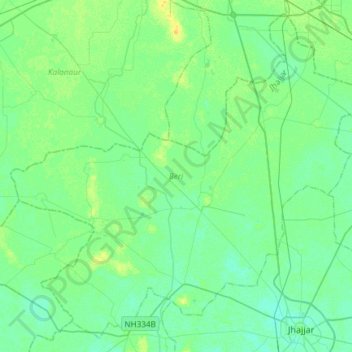
Name: Beri topographic map, elevation, terrain.

Location: Beri, Jhajjar, Haryana, India (28.59948 76.41263 28.83999 76.70952)

Average elevation: 719 ft

Minimum elevation: 699 ft

Maximum elevation: 761 ft

Gear up for your next adventure:

🦶Carbon Trekking Poles - Reduce knee impact on steep descents with ultra-light poles
🌎3D Topographic Globes - Raised relief globes for a tactile understanding of geography
📻Weather Alert Radios - Stay informed of storm risks while off-the-grid
🪄Magnetic Compass - Accurate compass for navigation
🎒Day Hiking Backpack - Lightweight backpack perfect for day trips and outdoor adventures

As an Amazon Associate, this site earns from qualifying purchases at no extra cost to you.