
Make a donation
Gear up for your next adventure:
As an Amazon Associate, this site earns from qualifying purchases at no extra cost to you.
Teutheuvel topographic map
Click on the map to display elevation.
Make a donation
Gear up for your next adventure:
As an Amazon Associate, this site earns from qualifying purchases at no extra cost to you.
About this map
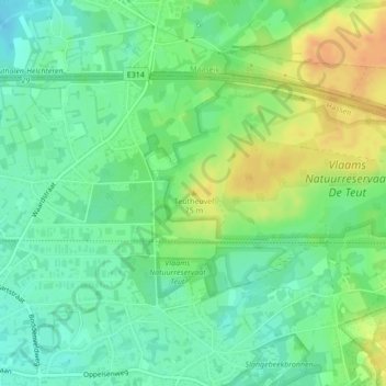
Name: Teutheuvel topographic map, elevation, terrain.
Location: Teutheuvel, Zonhoven, Hasselt, Limburg, Vlaanderen, 3520, België (51.00417 5.40028 51.00427 5.40038)
Average elevation: 184 ft
Minimum elevation: 135 ft
Maximum elevation: 256 ft
Make a donation
Gear up for your next adventure:
As an Amazon Associate, this site earns from qualifying purchases at no extra cost to you.
Other topographic maps
Click on a map to view its topography, its elevation and its terrain.
Zonhoven
België > Limburg > Hasselt > Zonhoven
De N74 snijdt de gemeente Zonhoven in twee delen. Deze gewestweg loopt van Hasselt tot aan de Nederlandse grens in het noorden. Hij staat bekend als de Limburgse Noord-Zuidverbinding. De gehuchten Halveweg en Terdonk liggen ten oosten van de weg en zijn zo van de rest van de gemeente afgesloten. Sinds de jaren…
Average elevation: 151 ft