
Make a donation
Gear up for your next adventure:
As an Amazon Associate, this site earns from qualifying purchases at no extra cost to you.
Mount Aniakchak topographic map
Click on the map to display elevation.
Make a donation
Gear up for your next adventure:
As an Amazon Associate, this site earns from qualifying purchases at no extra cost to you.
Mount Aniakchak
Milky-green Surprise Lake has an area of 2.75 square kilometers (1.06 sq mi) and abuts the inner northeastern margin of the caldera. Its water is about 19.5 meters (64 ft) deep and originates from various hot springs, cold springs and meltwater. Lake waters are continually mixed by strong winds. Hydrothermal inputs give the lake its color. The lake, which formed behind the deltas of several creeks, drains through The Gates valley at 335 meters (1,099 ft) elevation above sea level in the eastern caldera rim, the only outlet of the caldera. The outlet forms the Aniakchak River, a National Wild and Scenic River flowing to the Pacific Ocean. In 2010, one of the maars in the caldera broke out, causing a flood in the Aniakchak River. Meshik Lake is south of the caldera. The Meshik and Cinder Rivers drain the rest of the volcanic edifice, to Bristol Bay. A 1 square kilometer (0.39 sq mi) debris-covered glacier is in the southern sector of the caldera and has emplaced moraines. Other small glaciers have developed on Aniakchak Peak and Vent Mountain. Landslides have affected the eastern walls of the caldera.
Make a donation
Gear up for your next adventure:
As an Amazon Associate, this site earns from qualifying purchases at no extra cost to you.
About this map
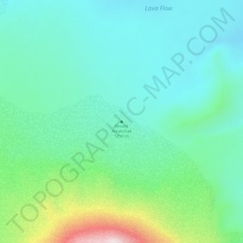
Name: Mount Aniakchak topographic map, elevation, terrain.
Average elevation: 1,585 ft
Minimum elevation: 1,171 ft
Maximum elevation: 2,917 ft
Lake and Peninsula Borough trails, hiking, mountain biking, running and outdoor activities
Make a donation
Gear up for your next adventure:
As an Amazon Associate, this site earns from qualifying purchases at no extra cost to you.
Other topographic maps
Click on a map to view its topography, its elevation and its terrain.
Make a donation
Gear up for your next adventure:
As an Amazon Associate, this site earns from qualifying purchases at no extra cost to you.