Geolocate

Portage topographic map

Click on the map to display elevation.

About this map

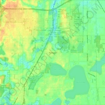
Name: Portage topographic map, elevation, terrain.

Location: Portage, Kalamazoo County, Michigan, United States (42.15732 -85.64829 42.24528 -85.53034)

Average elevation: 873 ft

Minimum elevation: 823 ft

Maximum elevation: 938 ft

Kalamazoo County trails, hiking, mountain biking, running and outdoor activities

Other topographic maps

Click on a map to view its topography, its elevation and its terrain.

Comstock

United States > Michigan > Kalamazoo County

Average elevation: 814 ft

East Comstock

United States > Michigan > Kalamazoo County

Average elevation: 823 ft

Gear up for your next adventure:

🧥Men's Rain Shells - Premium waterproof and breathable jackets for mountain weather
🥾Women's Hiking Boots - Top-rated trail boots with ankle support and superior grip
😴Insulated Sleeping Pads - Compact and warm pads for high-elevation camping
☀️Outdoor Sunscreen - High protection sunscreen for outdoor activities
🧢Outdoor Hiking Hat - Sun protection hat for outdoor explorers

As an Amazon Associate, this site earns from qualifying purchases at no extra cost to you.