
Thank you for supporting this site ❤️
Make a donation
Make a donation
Gear up for your next adventure:
As an Amazon Associate, this site earns from qualifying purchases at no extra cost to you.
Alta Floresta topographic map
Click on the map to display elevation.
Thank you for supporting this site ❤️
Make a donation
Make a donation
Gear up for your next adventure:
As an Amazon Associate, this site earns from qualifying purchases at no extra cost to you.
Alta Floresta
O município de Alta Floresta possui uma área de 8 947,07 km² e está localizado no extremo norte do estado de Mato Grosso, a 830 km da capital do estado, Cuiabá. Fica a 283 metros de altitude.
Thank you for supporting this site ❤️
Make a donation
Make a donation
Gear up for your next adventure:
As an Amazon Associate, this site earns from qualifying purchases at no extra cost to you.
About this map
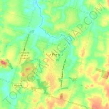
Name: Alta Floresta topographic map, elevation, terrain.
Average elevation: 906 ft
Minimum elevation: 807 ft
Maximum elevation: 1,043 ft
Thank you for supporting this site ❤️
Make a donation
Make a donation
Gear up for your next adventure:
As an Amazon Associate, this site earns from qualifying purchases at no extra cost to you.