
Panguitch topographic map
Click on the map to display elevation.
Panguitch
Panguitch was first settled in March 1864, when Jens Nielsen, a Danish convert to The Church of Jesus Christ of Latter-day Saints, led a group of 54 families eastward from Parowan and Beaver to the Sevier River. Due to the area's high elevation, 6,600 feet (2,000 m) above sea level, winter's cold weather arrived early in the year, and the most of the settlers' initial crops were killed by frost before they could mature. At a crisis point, seven men left the community to seek flour and foodstuffs from surrounding communities. Heavy snow forced the abandonment of wagons and teams, and the men finished their rescue mission on foot, reportedly by laying one quilt after another upon the snow to maintain their footing.
About this map
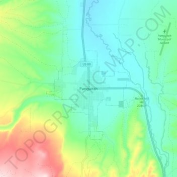
Name: Panguitch topographic map, elevation, terrain.
Location: Panguitch, Garfield County, Utah, 87459, United States (37.78276 -112.47576 37.86276 -112.39576)
Average elevation: 6,827 ft
Minimum elevation: 6,519 ft
Maximum elevation: 7,618 ft
Garfield County trails, hiking, mountain biking, running and outdoor activities