
Thank you for supporting this site ❤️
Make a donation
Make a donation
Gear up for your next adventure:
As an Amazon Associate, this site earns from qualifying purchases at no extra cost to you.
Nevado Sajama topographic map
Click on the map to display elevation.
Thank you for supporting this site ❤️
Make a donation
Make a donation
Gear up for your next adventure:
As an Amazon Associate, this site earns from qualifying purchases at no extra cost to you.
About this map
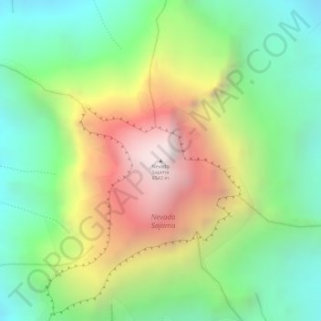
Name: Nevado Sajama topographic map, elevation, terrain.
Average elevation: 19,032 ft
Minimum elevation: 17,234 ft
Maximum elevation: 21,493 ft
Thank you for supporting this site ❤️
Make a donation
Make a donation
Gear up for your next adventure:
As an Amazon Associate, this site earns from qualifying purchases at no extra cost to you.
Other topographic maps
Click on a map to view its topography, its elevation and its terrain.
Caripe
Bolivia > Oruro > Provincia Sajama > Municipio Curahuara de Carangas
Average elevation: 13,802 ft
Lagunas
Bolivia > Oruro > Provincia Sajama > Municipio Curahuara de Carangas
Average elevation: 13,566 ft