Geolocate

Luzerne topographic map

Click on the map to display elevation.

About this map

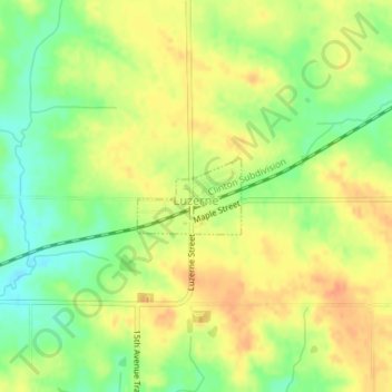
Name: Luzerne topographic map, elevation, terrain.

Location: Luzerne, Benton County, Iowa, United States (41.90360 -92.18594 41.90888 -92.17629)

Average elevation: 899 ft

Minimum elevation: 823 ft

Maximum elevation: 958 ft

Benton County trails, hiking, mountain biking, running and outdoor activities

Other topographic maps

Click on a map to view its topography, its elevation and its terrain.

Watkins

United States > Iowa > Benton County

Average elevation: 833 ft

Irving

United States > Iowa > Benton County

Average elevation: 850 ft

Gear up for your next adventure:

💧Water Purification System - Clean water on the trail with reliable purifiers
🕶️GPS Smartphone Mount - Secure mount for phone navigation
🪶Thermal Camp Blanket - Extra warmth for cold nights
🩹Survival Bandages - High‑quality bandages for emergencies
📚Navigation Handbooks - Master the art of reading topographic maps and using a compass

As an Amazon Associate, this site earns from qualifying purchases at no extra cost to you.