Geolocate

Paradise topographic map

Click on the map to display elevation.

About this map

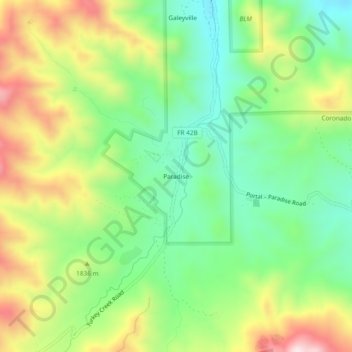
Name: Paradise topographic map, elevation, terrain.

Location: Paradise, Cochise County, Arizona, United States (31.91481 -109.23895 31.95481 -109.19895)

Average elevation: 5,850 ft

Minimum elevation: 5,177 ft

Maximum elevation: 6,883 ft

Cochise County trails, hiking, mountain biking, running and outdoor activities

Other topographic maps

Click on a map to view its topography, its elevation and its terrain.

Whetstone

United States > Arizona > Cochise County

Average elevation: 4,403 ft

St. David

United States > Arizona > Cochise County

Average elevation: 3,734 ft

Huachuca City

United States > Arizona > Cochise County

Average elevation: 4,360 ft

Whetstone

United States > Arizona > Cochise County

Average elevation: 4,344 ft

Gear up for your next adventure:

📡Handheld GPS Device - Reliable handheld GPS for outdoor navigation
👓Polarized Sunglasses - Outdoor sunglasses for glare reduction
📦Gear Storage Bags - Organize and protect outdoor equipment
🧴Hand Sanitizer - Keep hands clean while hiking
📌Outdoor GPS Map App - Apps and devices for digital topographic navigation

As an Amazon Associate, this site earns from qualifying purchases at no extra cost to you.