Geolocate

Mills topographic map

Click on the map to display elevation.

About this map

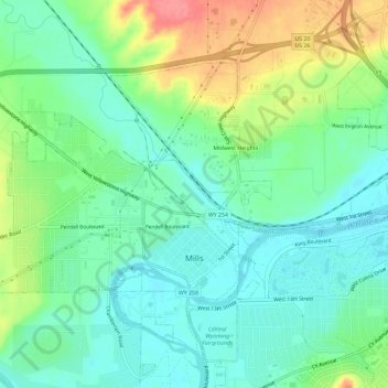
Name: Mills topographic map, elevation, terrain.

Location: Mills, Natrona County, Wyoming, United States (42.83440 -106.41477 42.86350 -106.35634)

Average elevation: 5,187 ft

Minimum elevation: 5,098 ft

Maximum elevation: 5,374 ft

Natrona County trails, hiking, mountain biking, running and outdoor activities

Other topographic maps

Click on a map to view its topography, its elevation and its terrain.

Mills

United States > Wyoming > Natrona County

Average elevation: 5,187 ft

Casper

United States > Wyoming > Natrona County > Casper

Average elevation: 5,666 ft

Casper

United States > Wyoming > Natrona County

Average elevation: 5,364 ft

Gear up for your next adventure:

🔭Compact Binoculars - HD vision for scouting terrain and identifying distant landmarks
GPS Sports Watch - GPS watch for running, hiking and training
🧭GPS Watch Accessories - Bands and chargers for GPS watches
📌Outdoor GPS Map App - Apps and devices for digital topographic navigation
Backpacking Tent - Lightweight and durable tent for multi‑day hikes

As an Amazon Associate, this site earns from qualifying purchases at no extra cost to you.