
Araras topographic map
Click on the map to display elevation.
About this map
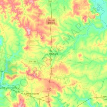
Name: Araras topographic map, elevation, terrain.
Average elevation: 2,146 ft
Minimum elevation: 1,824 ft
Maximum elevation: 2,687 ft
Other topographic maps
Click on a map to view its topography, its elevation and its terrain.
Parque Ecológico
Brasil > São Paulo > Região Metropolitana de Piracicaba > Araras
Average elevation: 2,070 ft
Praça Alianz
Brasil > São Paulo > Região Metropolitana de Piracicaba > Araras
Average elevation: 2,119 ft