Geolocate

Linao topographic map

Click on the map to display elevation.

About this map

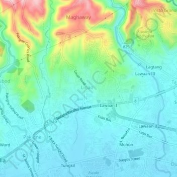
Name: Linao topographic map, elevation, terrain.

Location: Linao, Cebu, Central Visayas, 6045, Philippines (10.24199 123.79853 10.28199 123.83853)

Average elevation: 190 ft

Minimum elevation: 0 ft

Maximum elevation: 791 ft

Other topographic maps

Click on a map to view its topography, its elevation and its terrain.

Malapascua

Philippines > Cebu > Logon

Average elevation: 3 ft

Boljoon River

Philippines > Cebu > Boljoon > Lower Becerril

Average elevation: 210 ft

Cordova

Philippines > Cebu

The surface of the town consists entirely of karstic limestone rock geologically associated with the Plio-Pleistocene Carcar Formation, dated to 2½–3 million years ago. The topography of Cordova is flat land, the highest point being only 10 metres (33 ft) above sea level.

Average elevation: 0 ft

Toledo City Plaza

Philippines > Cebu > Toledo

Average elevation: 30 ft

Luyang River

Philippines > Cebu > Carmen

Average elevation: 190 ft

Gear up for your next adventure:

🔭Stargazing Telescopes - Perfect for camping in low-light pollution areas shown on maps
🧣Hiking Neck Gaiter - Multi‑use neck protection for outdoor weather
🪶Camping Sleeping Pad - Comfortable sleeping pad for backpacking
🏔️Mountain Trail Maps - High‑detail maps for popular peaks
🔥Fast-Boil Camping Stoves - Efficient cooking systems for quick trail meals

As an Amazon Associate, this site earns from qualifying purchases at no extra cost to you.