Geolocate

Maroero topographic map

Click on the map to display elevation.

About this map

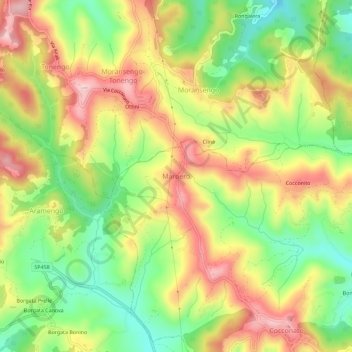
Name: Maroero topographic map, elevation, terrain.

Location: Maroero, Cocconato, Asti, Piemonte, 14023, Italia (45.08498 8.00145 45.12498 8.04145)

Average elevation: 1,175 ft

Minimum elevation: 787 ft

Maximum elevation: 1,578 ft

Gear up for your next adventure:

🥾Hiking Shoes - Durable and comfortable shoes for trail hiking
🔦Compact Flashlight - Reliable flashlight for emergencies
🕶️GPS Smartphone Mount - Secure mount for phone navigation
🥩Freeze-Dried Meals - Nutritious and lightweight food for remote expeditions
🧤Hiking Gloves - Protective gloves for rugged trails

As an Amazon Associate, this site earns from qualifying purchases at no extra cost to you.