Geolocate

Long Ashton topographic map

Click on the map to display elevation.

About this map

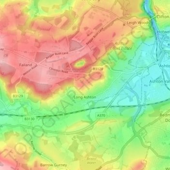
Name: Long Ashton topographic map, elevation, terrain.

Location: Long Ashton, North Somerset, England, United Kingdom (51.40736 -2.70131 51.46035 -2.62580)

Average elevation: 269 ft

Minimum elevation: -26 ft

Maximum elevation: 545 ft

Other topographic maps

Click on a map to view its topography, its elevation and its terrain.

Farleigh

United Kingdom > England > North Somerset > Backwell

Average elevation: 226 ft

Lower Failand

United Kingdom > England > North Somerset

Average elevation: 295 ft

Hounsley Batch

United Kingdom > England > North Somerset > Regil

Average elevation: 381 ft

Naish Hill

United Kingdom > England > North Somerset > Portbury

Average elevation: 217 ft

Lower Langford

United Kingdom > England > North Somerset

Average elevation: 157 ft

Highridge

United Kingdom > England > North Somerset > Dundry

Average elevation: 374 ft

Upper Canada

United Kingdom > England > North Somerset > Hutton

Average elevation: 157 ft

Stock

United Kingdom > England > North Somerset > Langford

Average elevation: 95 ft

West Hewish

United Kingdom > England > North Somerset > Hewish

Average elevation: 16 ft

Rickford

United Kingdom > England > North Somerset

Average elevation: 381 ft

South Hill

United Kingdom > England > North Somerset > Bleadon

Average elevation: 92 ft

North End

United Kingdom > England > North Somerset > Yatton

Average elevation: 20 ft

Elborough

United Kingdom > England > North Somerset > Hutton

Average elevation: 128 ft

Sandford

United Kingdom > England > North Somerset

Average elevation: 121 ft

Sidcot

United Kingdom > England > North Somerset > Winscombe

Average elevation: 338 ft

North Weston

United Kingdom > England > North Somerset > Portishead

Average elevation: 102 ft

Dinghurst

United Kingdom > England > North Somerset > Langford > Dinghurst

Average elevation: 259 ft

Brinsea

United Kingdom > England > North Somerset > Congresbury > Brinsea

Average elevation: 66 ft

Yanley

United Kingdom > England > North Somerset > Long Ashton

Average elevation: 217 ft

Blagdon Lake

United Kingdom > England > North Somerset > Blagdon

Average elevation: 246 ft

Upper Canada

United Kingdom > England > North Somerset > Hutton

Average elevation: 157 ft

Redhill

United Kingdom > England > North Somerset

Average elevation: 400 ft

North Weston

United Kingdom > England > North Somerset > Portishead

Average elevation: 102 ft

Yanley

United Kingdom > England > North Somerset > Long Ashton

Average elevation: 217 ft

Gear up for your next adventure:

🔭Compact Binoculars - HD vision for scouting terrain and identifying distant landmarks
🥩Freeze-Dried Meals - Nutritious and lightweight food for remote expeditions
🔦Compact Flashlight - Reliable flashlight for emergencies
🗺️Topographic Maps - Detailed topo maps for hiking, exploring and outdoor navigation
Backpacking Tents - Weight-optimized shelters for multi-day topographic surveys

As an Amazon Associate, this site earns from qualifying purchases at no extra cost to you.