
Thank you for supporting this site ❤️
Make a donation
Make a donation
Gear up for your next adventure:
As an Amazon Associate, this site earns from qualifying purchases at no extra cost to you.
Corte topographic map
Click on the map to display elevation.
Thank you for supporting this site ❤️
Make a donation
Make a donation
Gear up for your next adventure:
As an Amazon Associate, this site earns from qualifying purchases at no extra cost to you.
About this map
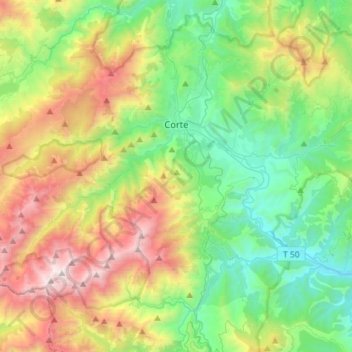
Name: Corte topographic map, elevation, terrain.
Location: Corte, Haute-Corse, Corsica, Metropolitan France, 20250, France (42.20317 8.92650 42.34467 9.21178)
Average elevation: 3,829 ft
Minimum elevation: 725 ft
Maximum elevation: 8,786 ft
Thank you for supporting this site ❤️
Make a donation
Make a donation
Gear up for your next adventure:
As an Amazon Associate, this site earns from qualifying purchases at no extra cost to you.