
Torfhaus topographic map
Click on the map to display elevation.
About this map
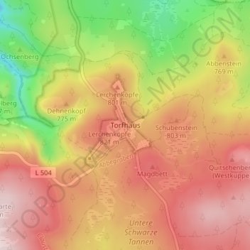
Name: Torfhaus topographic map, elevation, terrain.
Average elevation: 2,454 ft
Minimum elevation: 1,742 ft
Maximum elevation: 2,986 ft
Other topographic maps
Click on a map to view its topography, its elevation and its terrain.
Schulenberg im Oberharz
Germany > Lower Saxony > Landkreis Goslar > Clausthal-Zellerfeld
Average elevation: 1,719 ft
Altenau
Germany > Lower Saxony > Landkreis Goslar > Clausthal-Zellerfeld
Altenau is an old mining town.1227 First mentioned in connection with mining. In 1298 there was a smelting company in the Tischlertal, which was handed over to the Goslarer Burchard Erhaftig by Burchard von Wildenstein. This hut stands in 1310 and is run by Albrecht Colven. 1412 Construction of a house…
Average elevation: 1,965 ft