
Teuchatz topographic map
Click on the map to display elevation.
Teuchatz
Teuchatz hat 221 Einwohner, liegt auf 545 m ü. NN und ist damit eine der am höchsten gelegenen Ortschaften im Landkreis Bamberg. Die Ortschaft liegt in einer kleinen Senke (545 Meter über Normalnull) am Rande des westlichen Höhenzugs der Fränkischen Alb. Am Ortsrand steigt das Gelände mit dem Veitsknock auf 565 Meter. Zwischen den beiden Ortschaften Teuchatz und Tiefenpölz erhebt sich auf gleicher Höhe wie Teuchatz der Seigelstein.
About this map
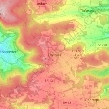
Name: Teuchatz topographic map, elevation, terrain.
Average elevation: 1,657 ft
Minimum elevation: 1,171 ft
Maximum elevation: 1,962 ft
Other topographic maps
Click on a map to view its topography, its elevation and its terrain.
91332
Deutschland > Bayern > Landkreis Bamberg > Heiligenstadt i. OFr. > Burggrub
Average elevation: 1,555 ft