
Biggar topographic map
Click on the map to display elevation.
Biggar
Biggar has an oceanic climate (Köppen: Cfb). Camps Reservoir is a nearby weather station situated at an elevation of 295 m (968 ft).
About this map
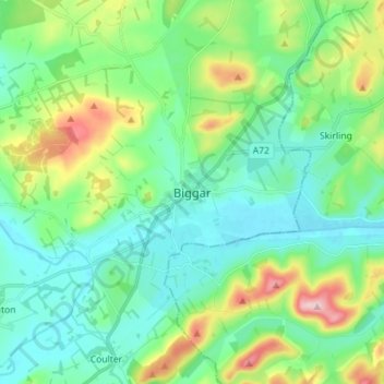
Name: Biggar topographic map, elevation, terrain.
Location: Biggar, South Lanarkshire, Scotland, ML12 6DH, United Kingdom (55.58449 -3.56158 55.66449 -3.48158)
Average elevation: 833 ft
Minimum elevation: 633 ft
Maximum elevation: 1,414 ft
Other topographic maps
Click on a map to view its topography, its elevation and its terrain.
Clyde Valley Family Park's Island
United Kingdom > Scotland > South Lanarkshire > Hazelbank > Birkhill
Average elevation: 390 ft
Langlands Moss Lowland Raised Peatbog
United Kingdom > Scotland > South Lanarkshire > East Kilbride
Average elevation: 669 ft
Craignethan Castle
United Kingdom > Scotland > South Lanarkshire > Crossford > Tillietudlem
Average elevation: 397 ft
Langlands Moss Local Nature Reserve
United Kingdom > Scotland > South Lanarkshire > East Kilbride
Average elevation: 669 ft
Trough Linn Woodlands Project
United Kingdom > Scotland > South Lanarkshire > East Kilbride
Average elevation: 607 ft
Low Banks
United Kingdom > Scotland > South Lanarkshire > Lamington > Millhill
Average elevation: 863 ft