
Make a donation
Gear up for your next adventure:
As an Amazon Associate, this site earns from qualifying purchases at no extra cost to you.
La Libertad topographic map
Click on the map to display elevation.
Make a donation
Gear up for your next adventure:
As an Amazon Associate, this site earns from qualifying purchases at no extra cost to you.
La Libertad
Su topografía por lo general es plana, y a las llanuras en donde se ubica la cabecera municipal se les denomina «sabana». Las montañas que atraviesan el municipio forman parte de la Sierra del Lacandón.
Make a donation
Gear up for your next adventure:
As an Amazon Associate, this site earns from qualifying purchases at no extra cost to you.
About this map
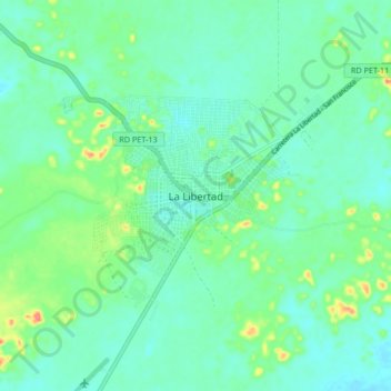
Name: La Libertad topographic map, elevation, terrain.
Location: La Libertad, Petén, 17023, Guatemala (16.74740 -90.15832 16.82740 -90.07832)
Average elevation: 623 ft
Minimum elevation: 571 ft
Maximum elevation: 784 ft
Make a donation
Gear up for your next adventure:
As an Amazon Associate, this site earns from qualifying purchases at no extra cost to you.