Geolocate

Jish topographic map

Click on the map to display elevation.

About this map

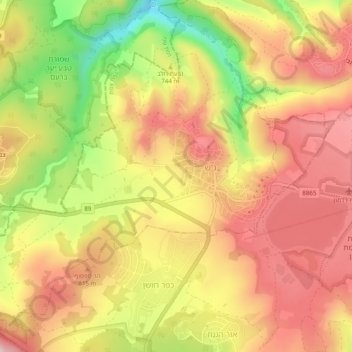
Name: Jish topographic map, elevation, terrain.

Location: Jish, Safed Subdistrict, North District, Israel (33.00539 35.40650 33.04144 35.45506)

Average elevation: 2,464 ft

Minimum elevation: 1,827 ft

Maximum elevation: 2,864 ft

Gear up for your next adventure:

👟Trail Running Shoes - Lightweight shoes for trail runners
👟Men's Trail Runners - Lightweight footwear for fast-paced exploration and light hiking
Backpacking Tents - Weight-optimized shelters for multi-day topographic surveys
🧭GPS Watch Accessories - Bands and chargers for GPS watches
🌡️Portable Weather Meter - Track weather conditions on the trail

As an Amazon Associate, this site earns from qualifying purchases at no extra cost to you.