
Make a donation
Gear up for your next adventure:
As an Amazon Associate, this site earns from qualifying purchases at no extra cost to you.
Umgeni River topographic map
Click on the map to display elevation.
Make a donation
Gear up for your next adventure:
As an Amazon Associate, this site earns from qualifying purchases at no extra cost to you.
About this map
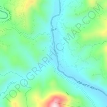
Name: Umgeni River topographic map, elevation, terrain.
Average elevation: 1,122 ft
Minimum elevation: 787 ft
Maximum elevation: 2,139 ft
Make a donation
Gear up for your next adventure:
As an Amazon Associate, this site earns from qualifying purchases at no extra cost to you.
Other topographic maps
Click on a map to view its topography, its elevation and its terrain.
eThekwini Ward 25
South Africa > KwaZulu-Natal > eThekwini Metropolitan Municipality
Average elevation: 236 ft
Natal Bay
South Africa > KwaZulu-Natal > eThekwini Metropolitan Municipality > Durban
Average elevation: 13 ft
Shongweni Dam
South Africa > KwaZulu-Natal > eThekwini Metropolitan Municipality
Average elevation: 1,237 ft
uMhlangane River
South Africa > KwaZulu-Natal > eThekwini Metropolitan Municipality > KwaMashu
Average elevation: 312 ft
Make a donation
Gear up for your next adventure:
As an Amazon Associate, this site earns from qualifying purchases at no extra cost to you.
eThekwini Ward 97
South Africa > KwaZulu-Natal > eThekwini Metropolitan Municipality
Average elevation: 138 ft
eThekwini Ward 99
South Africa > KwaZulu-Natal > eThekwini Metropolitan Municipality
Average elevation: 318 ft