Geolocate

Castelletto topographic map

Click on the map to display elevation.

About this map

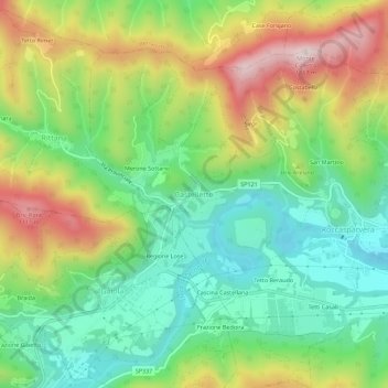
Name: Castelletto topographic map, elevation, terrain.

Location: Castelletto, Roccasparvera, Cuneo, Piedmont, Italy (44.32519 7.39860 44.36519 7.43860)

Average elevation: 2,687 ft

Minimum elevation: 2,008 ft

Maximum elevation: 3,766 ft

Other topographic maps

Click on a map to view its topography, its elevation and its terrain.

Bosia

Italy > Piedmont > Cuneo

Average elevation: 1,670 ft

Niella Tanaro

Italy > Piedmont > Cuneo

Average elevation: 1,385 ft

Sale San Giovanni

Italy > Piedmont > Cuneo

Average elevation: 1,919 ft

Alto

Italy > Piedmont > Cuneo

Average elevation: 2,546 ft

Montà

Italy > Piedmont > Cuneo

Average elevation: 991 ft

Montaldo Roero

Italy > Piedmont > Cuneo

Average elevation: 1,020 ft

Costigliole Saluzzo

Italy > Piedmont > Cuneo

Average elevation: 1,644 ft

Mombasiglio

Italy > Piedmont > Cuneo

Average elevation: 1,985 ft

Ormea

Italy > Piedmont > Cuneo

Average elevation: 3,957 ft

Santo Stefano Belbo

Italy > Piedmont > Cuneo > Santo Stefano Belbo

Average elevation: 1,060 ft

Viola

Italy > Piedmont > Cuneo

Average elevation: 3,448 ft

Monteu Roero

Italy > Piedmont > Cuneo

Average elevation: 1,007 ft

Sampeyre

Italy > Piedmont > Cuneo > Sampeyre

Average elevation: 5,643 ft

Macra

Italy > Piedmont > Cuneo

Average elevation: 4,636 ft

Lisio

Italy > Piedmont > Cuneo

Average elevation: 2,612 ft

Gear up for your next adventure:

🪶Wildlife Field Guides - Learn animal tracking and species ID
🥘Titanium Cookware - Durable, featherlight pots and pans for backpacking
📶Vehicle Signal Boosters - Improve reception in rural areas while driving to trailheads
🔥Plasma Lighters - Windproof lighters that work in any weather condition
🌐World Map Poster - Decorative world maps with topographic info

As an Amazon Associate, this site earns from qualifying purchases at no extra cost to you.