
Thank you for supporting this site ❤️
Make a donation
Make a donation
Gear up for your next adventure:
As an Amazon Associate, this site earns from qualifying purchases at no extra cost to you.
Talstraße/Trillerberg topographic map
Click on the map to display elevation.
Thank you for supporting this site ❤️
Make a donation
Make a donation
Gear up for your next adventure:
As an Amazon Associate, this site earns from qualifying purchases at no extra cost to you.
About this map
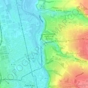
Name: Talstraße/Trillerberg topographic map, elevation, terrain.
Average elevation: 942 ft
Minimum elevation: 850 ft
Maximum elevation: 1,125 ft
Thank you for supporting this site ❤️
Make a donation
Make a donation
Gear up for your next adventure:
As an Amazon Associate, this site earns from qualifying purchases at no extra cost to you.
Other topographic maps
Click on a map to view its topography, its elevation and its terrain.
FFH Mittleres Zwickauer Muldetal (Teilfläche 2: Mulde südlich Glauchau)
Deutschland > Sachsen > Zwickau > Zwickau
Average elevation: 906 ft