
Thank you for supporting this site ❤️
Make a donation
Make a donation
Gear up for your next adventure:
As an Amazon Associate, this site earns from qualifying purchases at no extra cost to you.
Warken topographic map
Click on the map to display elevation.
Thank you for supporting this site ❤️
Make a donation
Make a donation
Gear up for your next adventure:
As an Amazon Associate, this site earns from qualifying purchases at no extra cost to you.
About this map
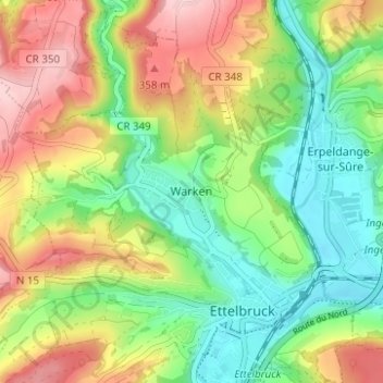
Name: Warken topographic map, elevation, terrain.
Location: Warken, Ettelbruck, Canton Diekirch, 9018, Luxembourg (49.83948 6.07017 49.87948 6.11017)
Average elevation: 902 ft
Minimum elevation: 630 ft
Maximum elevation: 1,283 ft
Thank you for supporting this site ❤️
Make a donation
Make a donation
Gear up for your next adventure:
As an Amazon Associate, this site earns from qualifying purchases at no extra cost to you.