
Santa Rosa Island topographic map
Click on the map to display elevation.
About this map
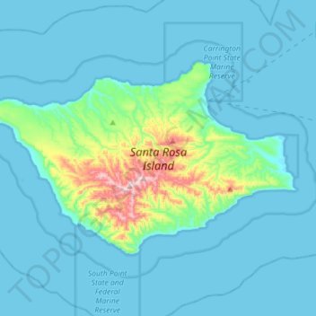
Name: Santa Rosa Island topographic map, elevation, terrain.
Average elevation: 167 ft
Minimum elevation: -3 ft
Maximum elevation: 1,568 ft
Santa Barbara County trails, hiking, mountain biking, running and outdoor activities
Other topographic maps
Click on a map to view its topography, its elevation and its terrain.
Vandenberg Village
United States > California > Santa Barbara County > Lompoc
Average elevation: 433 ft
North Santa Maria
United States > California > Santa Barbara County > Santa Maria
Average elevation: 213 ft
Jalama Beach County Park
United States > California > Santa Barbara County > Jalama
Average elevation: 131 ft
North Santa Maria
United States > California > Santa Barbara County > Santa Maria
Average elevation: 213 ft
Shoreline Park
United States > California > Santa Barbara County > Santa Barbara
Average elevation: 69 ft
Las Positas Meadows
United States > California > Santa Barbara County > Santa Barbara
Average elevation: 217 ft