
Make a donation
Gear up for your next adventure:
As an Amazon Associate, this site earns from qualifying purchases at no extra cost to you.
Mangaluru topographic map
Click on the map to display elevation.
Make a donation
Gear up for your next adventure:
As an Amazon Associate, this site earns from qualifying purchases at no extra cost to you.
Mangaluru
Mangaluru is included as one of the cities in the Smart Cities Mission list and is among the 100 smart cities to be developed in India. It has an average elevation of 22 m (72 ft) above mean sea level. It has a tropical monsoon climate and is under the influence of the southwest monsoon. It has its own international airport which is around 15km from the city centre.
Make a donation
Gear up for your next adventure:
As an Amazon Associate, this site earns from qualifying purchases at no extra cost to you.
About this map
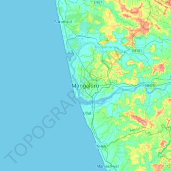
Name: Mangaluru topographic map, elevation, terrain.
Average elevation: 82 ft
Minimum elevation: -7 ft
Maximum elevation: 673 ft
Make a donation
Gear up for your next adventure:
As an Amazon Associate, this site earns from qualifying purchases at no extra cost to you.
Other topographic maps
Click on a map to view its topography, its elevation and its terrain.
Make a donation
Gear up for your next adventure:
As an Amazon Associate, this site earns from qualifying purchases at no extra cost to you.