Geolocate

Hunsur topographic map

Click on the map to display elevation.

Hunsur

Hunsur is located at 12°19′N 76°17′E / 12.31°N 76.29°E / 12.31; 76.29. It is located at an elevation of 805 metres (2,641 ft) above mean sea level. The river Lakshmana Tirtha flows through the town and two bridges are built across the river. The town is the administrative center of Hunsur taluk, which is part of the Mysore District.

Wikipedia (CC-BY-SA 3.0)

About this map

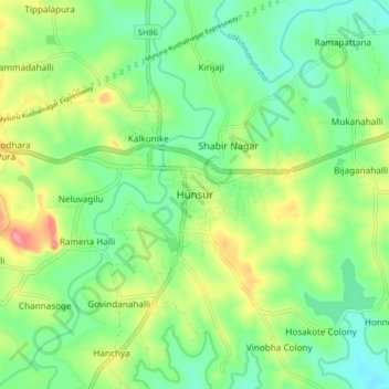
Name: Hunsur topographic map, elevation, terrain.

Location: Hunsur, Hunasuru taluk, Mysuru District, Karnataka, 571105, India (12.26351 76.25281 12.34351 76.33281)

Average elevation: 2,598 ft

Minimum elevation: 2,487 ft

Maximum elevation: 2,799 ft

Gear up for your next adventure:

📶Vehicle Signal Boosters - Improve reception in rural areas while driving to trailheads
🗃️Trail First Aid Kit - Essential kit for outdoor injuries and emergencies
🪶Paracord Bracelet - Survival bracelet with built‑in tools
📡GPS Antenna Upgrade - Enhance GPS reception in remote terrain
🎒Hydration Pack - Hands‑free water reservoir for long hikes

As an Amazon Associate, this site earns from qualifying purchases at no extra cost to you.