Geolocate

Crane topographic map

Click on the map to display elevation.

About this map

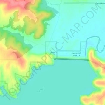
Name: Crane topographic map, elevation, terrain.

Location: Crane, Montgomery County, Kansas, United States (37.25951 -95.81693 37.29951 -95.77693)

Average elevation: 837 ft

Minimum elevation: 751 ft

Maximum elevation: 1,030 ft

Montgomery County trails, hiking, mountain biking, running and outdoor activities

Other topographic maps

Click on a map to view its topography, its elevation and its terrain.

Caney

United States > Kansas > Montgomery County

Average elevation: 758 ft

Elk City

United States > Kansas > Montgomery County

Average elevation: 837 ft

Coffeyville

United States > Kansas > Montgomery County

Average elevation: 751 ft

Independence

United States > Kansas > Montgomery County

Average elevation: 804 ft

Gear up for your next adventure:

🧤Tactile Hiking Gloves - Keep hands warm while operating GPS and smartphone screens
🥾Women's Hiking Boots - Top-rated trail boots with ankle support and superior grip
🪑Portable Camp Table - Compact table for campsite meals
🔭Stargazing Telescopes - Perfect for camping in low-light pollution areas shown on maps
📱Heavy-Duty Phone Cases - Drop-proof and waterproof protection for outdoor navigation

As an Amazon Associate, this site earns from qualifying purchases at no extra cost to you.