
Make a donation
Gear up for your next adventure:
As an Amazon Associate, this site earns from qualifying purchases at no extra cost to you.
Gornera topographic map
Click on the map to display elevation.
Make a donation
Gear up for your next adventure:
As an Amazon Associate, this site earns from qualifying purchases at no extra cost to you.
About this map
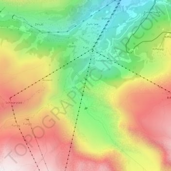
Name: Gornera topographic map, elevation, terrain.
Location: Gornera, Zermatt, Visp, Wallis, 3920, Switzerland (45.97788 7.72683 46.01117 7.74740)
Average elevation: 7,303 ft
Minimum elevation: 5,387 ft
Maximum elevation: 9,327 ft
Make a donation
Gear up for your next adventure:
As an Amazon Associate, this site earns from qualifying purchases at no extra cost to you.
Other topographic maps
Click on a map to view its topography, its elevation and its terrain.
Monte Rosa
Switzerland > Wallis > Visp > Zermatt
The peak is distinguished by the name Dufourspitze (in German, lit. Dufour Peak; French: Pointe Dufour, Italian: Punta Dufour). This replaced the former name Höchste Spitze (English: Highest Peak) that was indicated on the Swiss maps before the Federal Council, on January 28, 1863, decided to rename the…
Average elevation: 13,232 ft
Make a donation
Gear up for your next adventure:
As an Amazon Associate, this site earns from qualifying purchases at no extra cost to you.