
Make a donation
Gear up for your next adventure:
As an Amazon Associate, this site earns from qualifying purchases at no extra cost to you.
Alsput topographic map
Click on the map to display elevation.
Make a donation
Gear up for your next adventure:
As an Amazon Associate, this site earns from qualifying purchases at no extra cost to you.
About this map
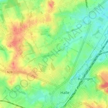
Name: Alsput topographic map, elevation, terrain.
Average elevation: 151 ft
Minimum elevation: 79 ft
Maximum elevation: 246 ft
Make a donation
Gear up for your next adventure:
As an Amazon Associate, this site earns from qualifying purchases at no extra cost to you.
Other topographic maps
Click on a map to view its topography, its elevation and its terrain.
Make a donation
Gear up for your next adventure:
As an Amazon Associate, this site earns from qualifying purchases at no extra cost to you.
Zuenbeek
Belgique > Brabant flamand > Hal-Vilvorde > Hal
Il prend sa source à Castre, à 70 m d'altitude, où il porte le nom de Bruggeplasbeek. Il traverse Pepingen où il reçoit les eaux du Karenbergbeek (ou Bosbeek) et porte le nom de Beringenbeek. Il passe ensuite à Oudenaken puis à Leeuw-Saint-Pierre, à Zuen et reçoit les eaux du Vogelzangbeek. Après une…
Average elevation: 167 ft