
Thank you for supporting this site ❤️
Make a donation
Make a donation
Gear up for your next adventure:
As an Amazon Associate, this site earns from qualifying purchases at no extra cost to you.
Unterbergscheid topographic map
Click on the map to display elevation.
Thank you for supporting this site ❤️
Make a donation
Make a donation
Gear up for your next adventure:
As an Amazon Associate, this site earns from qualifying purchases at no extra cost to you.
Unterbergscheid
Unterbergscheid liegt im westlichen Lindlar, östlich von Schmitzhöhe. Weitere Nachbarorte sind Oberbergscheid, Fahn, Ellersbach, Kepplermühle, Müllemich und Vellingen.
Thank you for supporting this site ❤️
Make a donation
Make a donation
Gear up for your next adventure:
As an Amazon Associate, this site earns from qualifying purchases at no extra cost to you.
About this map
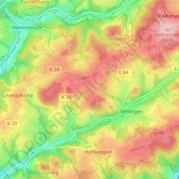
Name: Unterbergscheid topographic map, elevation, terrain.
Average elevation: 669 ft
Minimum elevation: 351 ft
Maximum elevation: 961 ft
Thank you for supporting this site ❤️
Make a donation
Make a donation
Gear up for your next adventure:
As an Amazon Associate, this site earns from qualifying purchases at no extra cost to you.