Geolocate

Gaville topographic map

Click on the map to display elevation.

About this map

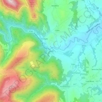
Name: Gaville topographic map, elevation, terrain.

Location: Gaville, Sassoferrato, Ancona, Marche, 60041, Italia (43.39177 12.79639 43.43177 12.83639)

Average elevation: 1,535 ft

Minimum elevation: 961 ft

Maximum elevation: 2,828 ft

Gear up for your next adventure:

📚USA Hiking Guide Books - Top trail guides and map books
🧦Hiking Socks - Comfortable socks to prevent blisters on long hikes
🪶Camping Sleeping Pad - Comfortable sleeping pad for backpacking
🔭Stargazing Telescopes - Perfect for camping in low-light pollution areas shown on maps
🗃️Trail First Aid Kit - Essential kit for outdoor injuries and emergencies

As an Amazon Associate, this site earns from qualifying purchases at no extra cost to you.