
Thank you for supporting this site ❤️
Make a donation
Make a donation
Gear up for your next adventure:
As an Amazon Associate, this site earns from qualifying purchases at no extra cost to you.
Vigan topographic map
Click on the map to display elevation.
Thank you for supporting this site ❤️
Make a donation
Make a donation
Gear up for your next adventure:
As an Amazon Associate, this site earns from qualifying purchases at no extra cost to you.
About this map
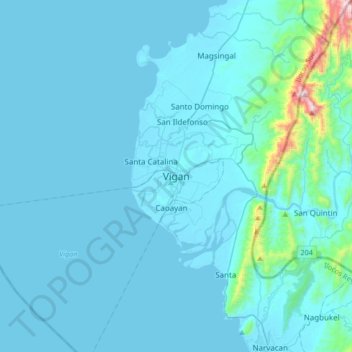
Name: Vigan topographic map, elevation, terrain.
Location: Vigan, Ilocos Sur, Ilocos Region, 2700, Philippines (17.41555 120.22726 17.73555 120.54726)
Average elevation: 207 ft
Minimum elevation: -3 ft
Maximum elevation: 3,537 ft
Thank you for supporting this site ❤️
Make a donation
Make a donation
Gear up for your next adventure:
As an Amazon Associate, this site earns from qualifying purchases at no extra cost to you.