
Waccabuc topographic map
Click on the map to display elevation.
About this map
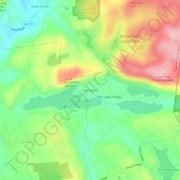
Name: Waccabuc topographic map, elevation, terrain.
Average elevation: 600 ft
Minimum elevation: 328 ft
Maximum elevation: 984 ft
Westchester County trails, hiking, mountain biking, running and outdoor activities
Other topographic maps
Click on a map to view its topography, its elevation and its terrain.
Goldens Bridge
United States > New York > Westchester County > Town of Lewisboro
Average elevation: 308 ft
Lake Waccabuc
United States > New York > Westchester County > Town of Lewisboro > Waccabuc
Average elevation: 568 ft