
Make a donation
Gear up for your next adventure:
As an Amazon Associate, this site earns from qualifying purchases at no extra cost to you.
Landsweiler-Reden topographic map
Click on the map to display elevation.
Make a donation
Gear up for your next adventure:
As an Amazon Associate, this site earns from qualifying purchases at no extra cost to you.
About this map
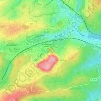
Name: Landsweiler-Reden topographic map, elevation, terrain.
Average elevation: 994 ft
Minimum elevation: 794 ft
Maximum elevation: 1,260 ft
Make a donation
Gear up for your next adventure:
As an Amazon Associate, this site earns from qualifying purchases at no extra cost to you.
Other topographic maps
Click on a map to view its topography, its elevation and its terrain.
Landsweiler-Reden
Deutschland > Saarland > Landkreis Neunkirchen > Schiffweiler
Average elevation: 997 ft
Heiligenwald
Deutschland > Saarland > Landkreis Neunkirchen > Schiffweiler
In Schiffweiler wurde 2014 ein Windpark errichtet. Der Park besteht aus fünf identischen Windkraftanlagen des Typs Vensys112. Die Nabenhöhe der Anlagen beträgt 140 Meter, der Rotordurchmesser beträgt 112 Meter, was einer Rotorkreisfläche von ca. 1 ha und einer Gesamthöhe von ca. 196 Meter entspricht. Die…
Average elevation: 1,056 ft
Stennweiler
Deutschland > Saarland > Landkreis Neunkirchen > Schiffweiler > Stennweiler
Average elevation: 1,122 ft
Make a donation
Gear up for your next adventure:
As an Amazon Associate, this site earns from qualifying purchases at no extra cost to you.