
Make a donation
Gear up for your next adventure:
As an Amazon Associate, this site earns from qualifying purchases at no extra cost to you.
Darlingtonia topographic map
Click on the map to display elevation.
Make a donation
Gear up for your next adventure:
As an Amazon Associate, this site earns from qualifying purchases at no extra cost to you.
About this map
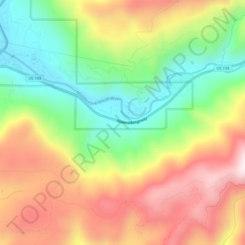
Name: Darlingtonia topographic map, elevation, terrain.
Location: Darlingtonia, Del Norte County, California, United States (41.81622 -123.96313 41.85622 -123.92313)
Average elevation: 1,427 ft
Minimum elevation: 331 ft
Maximum elevation: 2,664 ft
Del Norte County trails, hiking, mountain biking, running and outdoor activities
Make a donation
Gear up for your next adventure:
As an Amazon Associate, this site earns from qualifying purchases at no extra cost to you.
Other topographic maps
Click on a map to view its topography, its elevation and its terrain.
Crescent City
United States > California > Del Norte County
The topography of the sea floor surrounding Crescent City has the effect of focusing tsunamis. According to researchers at Humboldt State University and the University of Southern California, the city experienced tsunami conditions 31 times between the years 1933 and 2008. Although many of these incidents were…
Average elevation: 20 ft
Klamath
United States > California > Del Norte County
Klamath (Tolowa: Taa-chit) is an unincorporated, rural census-designated place (CDP) in Del Norte County, California, situated on US Route 101 inland from the mouth of the Klamath River. The current population of Klamath, California is 632 based on US Census estimates, down from 779 recorded in the 2010 US…
Average elevation: 623 ft
Crescent City
United States > California > Del Norte County
The topography of the sea floor surrounding Crescent City has the effect of focusing tsunamis. According to researchers at Humboldt State University and the University of Southern California, the city experienced tsunami conditions 31 times between the years 1933 and 2008. Although many of these incidents were…
Average elevation: 102 ft
Bertsch-Oceanview
United States > California > Del Norte County
Bertsch–Oceanview is a census-designated place (CDP) in Del Norte County, California, United States. The community is located east of Crescent City, at an elevation of 20 feet (6.1 m), Bertsch–Oceanview has a total area of 5.9 square miles (15 km2) of which 5.5 square miles (14 km2) is land and 0.3 square…
Average elevation: 180 ft
Make a donation
Gear up for your next adventure:
As an Amazon Associate, this site earns from qualifying purchases at no extra cost to you.
Smith River National Recreation Area
United States > California > Del Norte County
Average elevation: 2,362 ft